Chartplotter vs. iPad: Using your tablet or iPhone
As tablets and phones increase in power and capabilities, more and more sailors are turning to them for their primary navigation tools on board. They've got several short-term advantages over a more expensive chartplotter, and can be suitable solutions for small boats or budget conscious cruisers.
You can safely use your tablet or iPhone as a chartplotter, but you will need to take some extra steps to add more safety and you need to know about a few caveats. Dedicated chartplotters will typically have more functionality and be more stable than phones and tablets.
We'll talk about the strengths and weaknesses, and how you can backstop some of those weaknesses for a better solution.

You Can Use Your iPad or iPhone As a Chartplotter
You can safely use your iPad as a chartplotter. There are many good quality charting applications on the market now which provide safe and accurate navigation nearshore and offshore. You can purchase accurate, legitimate nautical charts and integrate applications with external instruments for more accuracy and better information in a single replacement for a chartplotter.
Most of the apps available for the iPad are also available for the iPhone, so you have an excellent selection of tools to choose from if you want to use your iPhone for navigation. Like the iPad, it's a matter of choosing the software you prefer, purchasing the charts you need, and enabling the GPS on your phone.
Some of the most popular apps are:
- Navionics Boating
- iNavX
- iSailor
- TimeZero iBoat
- C-Map
If your ship's instruments and your App choice support it, you can even get ship's sensor data like depth, wind and speed through the water on your phone, too.
Chartplotter and iPad Have Important Differences
A permanently installed chartplotter attached to your ship's instruments is a powerful tool, and years of use and testing have led to some very reliable and powerful systems design to withstand the rugged conditions on a boat offshore. Commercial fishermen and mariners rely on these tools with their lives daily.
But they're complex, expensive, and most people today have a smartphone and many have tablets. So what are the strengths and weaknesses of both?
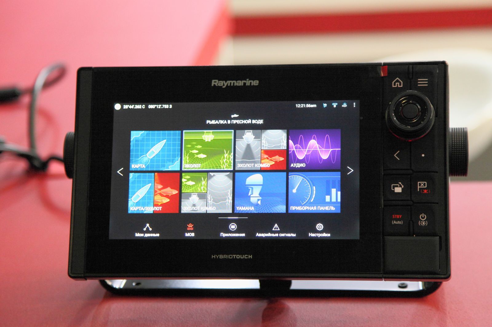
Pros and Cons of Chartplotters
Chartplotters are reliable and rugged. A list of their primary advantages includes:
Advantages of chartplotters:
- Good resistance to harsh marine conditions
- Designed for daylight viewing
- Contain many powerful navigation and safety tools
- Perform one function well, and are not compromised by outside factors, like other applications
- Integrate seamlessly with navigation tools and other very accurate electronics.
- They can show radar and radar overlays on charts
- Often have built-in tools for collision tracking with AIS and Radar targets.
But they aren't without drawbacks. The most important disadvantages of chartplotters are:
Disadvantages of chartplotters:
- Chartplotters are expensive. Even the smallest fixed mount multi-function displays start over $600 and the larger, more complex networked devices can run into thousands of dollars.
- Installation is complex. They need a power supply, a fixed mount, and external instrumentation, including a GPS data source. So you may end up cutting holes and running wires.
- They are single function. While you can take a few small handheld plotters off the boat, it still does nothing but navigation. Their strength - reliability - also means you put a lot of money into something you can't use for anything else.
- Because they are wired to the boat, they may be subject to catastrophic event like lightning strikes or power system failures, which may disable all installed electronics.
Pros and Cons of iPads
If you're reading this, there's a good chance you already had an iPad, or are thinking of one. It's good to know what they can do and what their limitations may be in a marine environment. Strengths include:
Advantages of iPad marine navigation:
- Low initial upfront cost. You may already own a device, but you can get an iPad with an internal GPS for a couple of hundred dollars.
- Simple installation - all you have to do is go to the Apple Store and buy the apps and their charts. If your vessel has a Wi-Fi gateway to its instruments (recommended!), you may have one more step configuring your apps to speak to them.
- Portable and easy to move around. On and off the boat, you may wish to work on your navigation away from that one spot where the chartplotter is screwed down.
- True multifunction devices - when you aren't navigating with them, the iPad is still...an iPad, and you can watch movies, read books, and do anything you usually do with it.
- You can tuck them in the microwave or oven to give them a chance of surviving a strike during a lightning storm.
But there are some disadvantages, too.
Disadvantages of iPad marine navigation:
- iPads do not come close to the water-resistance and durability of dedicated chartplotters. They are fragile, relatively speaking.
- Daytime viewability in bright sunlight - not uncommon when sailing - is often very poor.
- You can drop them overboard or lose them.
- The GPS does not have the same accuracy as most dedicated GPS antennas. The difference between +/- 1 meter and +/- 10 meter accuracy isn't much on a highway where you can't get lost, but it can be a huge problem in a narrow or unmarked seaway.
- Battery life with the screen on bright and the internal GPS on can be quite low.
- Apps which rely on cellular data to supply charts or other information will not work once you sail out of cell phone range.
- Other applications on a device may interfere with your navigation app.
The Solutions - Which is Best?
There is no clear and absolutely "which is best" answer. Much depends on you, your budget, your boat, and how and where you sail. The answer for a blue water cruiser in a big boat with ample power will be very different from for someone in a twenty-five foot pocket cruiser rarely sails over 50 miles from home.
If you are a blue water cruiser and you can afford and fit it, the recommendation is for a permanent chartplotter. You can not afford to lose your primary navigation. But it's also fair to say that if you DO lose your navigation, a handy iPad with navigation software is a great backup and can get you home safely. I've used an iPad with iNavX on it in just that capacity, as a back navigation tool, while I figured out why my ship’s instruments were on the blink on a passage.
But if you are leaning towards tablet or phone navigation, what can you do to offset some of those strong negatives?
Fix the tablet drawbacks:
- Get a waterproof case for your tablet.
- While there's not much to be done for daytime viewability, you can throw a dark shirt over your head and the tablet to improve bright light readability.
- Get a backup to your primary iPad, and have all the software you need installed on it. This can be a phone, but a second device is important.
- If you can't connect your iPad to your ship's GPS, think about a dedicated GPS antenna instead of the built-in GPS. This will give you better accuracy, and will also save battery power or allow you to navigate with a less expensive Wifi-only unit.
- Figure out how to get a charge cable to where you navigate, or carry a couple of rechargeable batteries to plug in the device.
- Only use an App which allows downloading charts for offline use and download the charts you need before you leave!
Does iPad & iPhone GPS work offshore?
The GPS in any device works by picking up satellite signals from anywhere in the world, so as long as you have a clear view of the sky, your GPS should work. Note that your cell phone data will NOT work offshore, and you will lose access to any online charts or resources you have, so plan accordingly.
How To Use an iPad or Tablet as a Chartplotter
In order to navigate with your iPad or Android tablet, you need three things on it:
- A navigation App
- Charts for that app for the area you plan to sail
- A GPS position, either the internal device GPS if it has one or from an outside source.
Once you have the software and charts you need, you can plot courses and start navigation.
Which apps work well?
The top selling and reviewed Apps in the App Store include Navionics Boating, iNavX, iSailor, TimeZero iBoat, and C-Map. Most are available for a small up-front cost and offer in-app purchases of additional charts beyond the initial trial period or basic free charts. In most cases, the U.S. Hydrographic Office charts of the coastal U.S. are included for little or no cost.
These are the most sophistic apps and include some means of speaking to networked ship's instruments and external data sources.
There are many less well-known apps on the market as well, and they may provide excellent solutions, but your mileage may vary. One popular free app is OpenCPN, an open source app used across multiple platforms. While it’s free, access to charts can be troublesome.
Pros and cons - Picking an App
Most of the applications have the same core functions, but they often differ in pricing models and availability of specific charts and features.
For example, Navionics charges a baseline subscription annually for the software, where iNavX costs $4.99 for the basic app and comes with access to U.S. charts. Other apps are free to download but require chart kit purchases. Navionics provides its own charts to users, and iNavX offers charts from multiple sources. Until recently you could buy Navionics charts through iNavX, but after Navionics was acquired by Garmin, they removed those charts from the iNavX chart store.
When considering an app, consider how and where you will use it and what features you prefer. If you sail in the U.S., chart availability will rarely be a problem. But if you sail some place like the Bahamas, the Explorer charts through iNavX are considered some of the best. If you sail in Europe or Canada, chart options will be a major factor in your choice.
Did you find the answer to your specific question?
👍 9 👎 0

Comments
Tim Millea
Great article, thank you.
I would just add that you can buy a used 12.9” iPad Pro with cellular and hence GPS for $/£ 300-400 on the Bay. Mount it at the chart table inside and the waterproofing and daylight visibility issues are gone. And just how much would a 13” colour chart plotter system cost? An iPad is easily upgradeable and can run many other apps that are helpful for passage-planning and communication.
Arend Jan Klinkhamer
Good overview!
I would not make an issue myself of the lower accuracy af the iPad GPS. If it would be 10m, that would be about half a boat width, and that is eyeball navigation anyway.
I have been using iPads for navigation for several years; right now I use a 12.9”as main device and a smaller one as a backup. With a sturdy watertight case and a permanent power supply cable it works good. The daylight visibility under the spray hood is sufficient and the brightness of iPads is increasing with every new model.
An issue I have with chart plotters is the uncertainty of the age of the chart material. There is no way to know up to what date the charts have been updated other than the purchase date. The only app I know of that is clear about the age of the charts is the Imray Navigator app. I would be glad to know if there are any chart suppliers that furnish this information. The Danish Hydrographis Office has threatened the chart suppliers to start developing its own navigation app because of this.
Margot Bax
You’ve done an impressive work on your website in covering the topic. I am working on content about Thai-Massage and thought you might like to check out <a href=”https://www.flightauto.ru/bitrix/redirect.php?goto=http://fq4.de/">FQ4</a> and let me what you think.
Leave a comment