What’s the Difference Between a Chartplotter and GPS?
When considering to buy my first electronic navigation device I wasn't sure if there was a difference between the GPS and chartplotter. So I did the research and decided to write an article.
What's the difference between GPS and a chartplotter? The use of a map to show your location. GPS provides your location, but it doesn't show it on a map. A chartplotter takes the GPS location and places it on top of a map. All chartplotters use GPS, but not all GPS are chartplotters.
Chartplotters sound like they're very helpful. My thought was to get one straight away and never look back. But it isn't as straightforward. Sometimes you rather have GPS and not a chartplotter. Or go even more old skool and use a boat compass for example.
Why Are They Different?
The terms GPS and chartplotter are very often used interchangeably, but there is a technical difference. Your TomTom and Google Maps are chartplotters. The technology that's inside your phone to calculate your position for Google Maps is GPS.
A GPS calculates your longitude and latitude coordinates, but it shows them in a number reading instead of on a map. If you've ever seen GPS coordinates you might recognize the format:
38° 58' 42.403" N 76° 29' 31.858" W
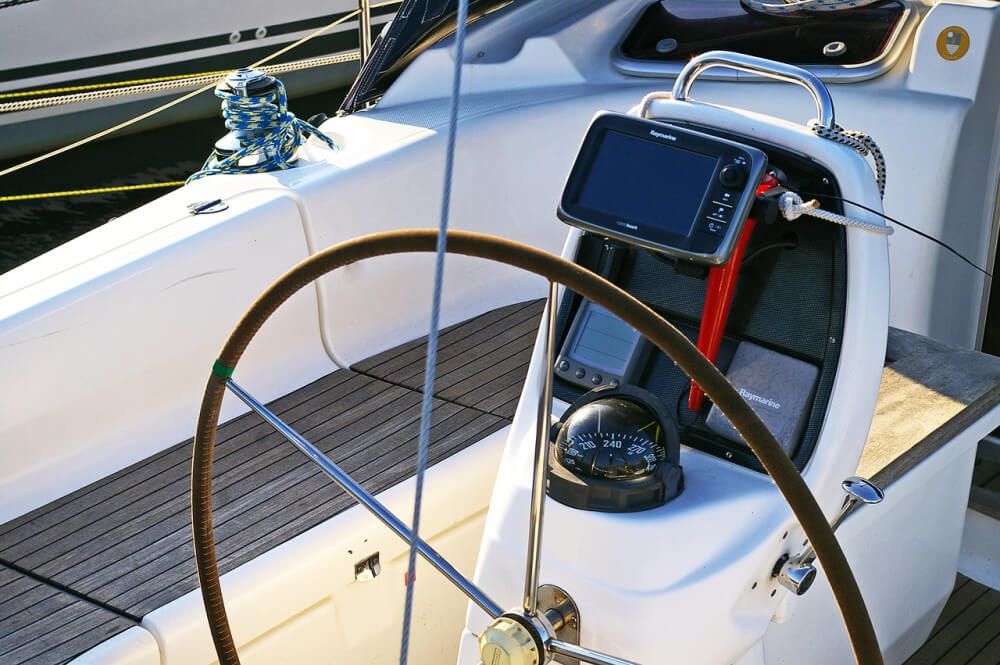
However hard I try, I'm not able to visualize my location based on this reading. That's what we need the chartplotter for. It knows how to take this data and plot it on a digital map. The main advantage of a chartplotter over GPS is ease of use. It's basically a user interface to allow us to use GPS.
All chartplotters use some sort of GPS to get your location. Some use internal GPS, others use external.
Nowadays, you can get a reliable, easy-to-use chartplotter, made by a reputable brand, with all the functionalities of an advanced marine GPS, at a fraction of the price. Click here to read my recommendation.
How does GPS work?
GPS stands for Global Positioning System (my guess is that you probably already knew that). A GPS system uses at least 24 satellites to pinpoint your location up to a couple of meters. Each satellite orbits the Earth twice a day and sends out its own signal.
The device you have in your boat is actually a GPS receiver, not a sending unit. The receiver measures your current distance from each satellite. With three or more satellites the receiver can calculate a very precise position.
If you'd only have a simple GPS unit you get just that: coordinates. It's not until a electronic device puts the location on a map or chart we can make sense of where we are: hence the name chartplotter.
How does a chartplotter work?
A chartplotter combines the GPS data with electronic charts. Generally you simply download these charts, or maps (payed or for free) from your computer onto the device. The maps are simply an interface to make it more easy for us humans to use GPS.
You can store hundreds of waypoints using the chartplotter, which together make up a route. These waypoints are actually stored as longitude and latitude coordinates. By remembering all these points it's able to compare your current position to the preset route. This helps you to navigate more easily.
A very basic chartplotter tells you your location and the direction you're heading. This is not the same as the direction you're pointing. It will also tell you your speed (Speed Over Ground).
What GPS and chartplotters can't do: it can't tell you the direction at which you are currently pointing, which can be unfortunate if you're trying to orientate yourself.. That's why I recommend to always have a compass as well.
Manual chart plotting
A chartplotter is basically an electronic version of the manual chart-plotting process. Sailors used to get by using paper charts for centuries. Plotting your location on a paper chart is a skill that's worth considering learning since it's a great and reliable navigation backup. You can either use GPS, just like the plotter, or pinpoint your location using points of reference and a compass.
A great starting point to learning to read nautical charts and plot your course, is our detailed guide on Nautical Chart Navigation.
What Do Chartplotters Cost?
A chartplotter can cost anything between $150 - $5,000. In comparison: you can get a very basic GPS device for about $70.
You don't have to spend thousands of dollars though. Most of the more expensive systems are actually MFDs (multifunctional displays), which are designed to do all sorts of things besides navigation, such as fish finding, sonar, and so on. They are cool - but if you don't use any other electronic systems, you might not need one.
There are basically three types of chartplotters:
- handheld chartplotters - $150 - $250
- mounted chartplotters - $250 - $500
- MFDs - multi functional displays - $500 and up
Handheld devices are great as they are small, easy to use, and cheap. They have a very small screen however. Mounted chartplotters are a bit bigger and come with more functionality. They allow you to store routes and display additional layers of info. Some can also be used with sonar.
If you're interested in my recommendation for the best bang for the buck mounted chartplotter, make sure to check out my chartplotter recommendation here.
More advanced MFD systems allow you to:
- set waypoints, program routes, and check your route history
- upload data to you computer using SD or USB cable
- monitor fuel, temperature, AIS
- system integration (the ability to talk to other systems on board, such as your autopilot)
- use sonar to show water depth, fish
- several alarm functions (route deviation, anchoring drift)
- weather report overlay
What's WAAS?
Some devices come with WAAS support, which is said to make it more accurate. WAAS means Wide Area Augmentation System, and it's a satellite based augmentation system. It uses a network of ground based reference stations, which is only available in Canada, the US and some other North American territories. So you can't use it anywhere else. Also, it's up for debate if it really matters that much. I know people that use WAAS and aren't sure if it does anything to increase their accuracy.
Europa has its own system called EGNOS; Japan has MSAS.
If you can get WAAS support without paying extra for it, or if it's on a device you'd want to get anyway, sure, go for it. But I'd be wary to pay extra for it.
Do I Need a Chartplotter?
At this point I was asking myself: do I need a chartplotter? They can be quite expensive and I don't need many of the advanced features.
The short answer is: no, you don't need a chartplotter for marine navigation. The long answer is: it depends.
There are a couple of clear advantages when using a chartplotter over more primitive navigational methods. The first one is accuracy: you can't beat it. Triangulating your position within a couple of centimeters is something you just won't manage to do consistently with just a compass and a paper chart. But this accuracy argument goes for any form of GPS, so any basic GPS would do the trick.
Where the chartplotter really falls behind is reliability. GPS works fine most of the time, especially at sea or large bodies of water, so I wouldn't worry about that too much. But if you have a power outage, you're suddenly without means of navigation.
It surprises me that some skippers go out on a trip without even bothering to bring alternative means of navigation, relying solely on their plotter. Every boat should have a compass and a skipper that knows how to use one. It's the most reliable method available. Also, bringing a backup GPS with some paper charts is a good way to just be safe instead of sorry.
Chartplotters are one of the easiest ways to get about. Especially if you plan on long trips where there are no points of reference (for example with blue water sailing), a chartplotter can be of great value. In this case, if you didn't bring a chartplotter, you have to manually plot your location from your GPS to your paper charts.
I find it easier to navigate using a large boat compass for the majority of the route. A chartplotter is great in getting you to the specific island once you're in range, but I just don't need all that detail for the most part.
A good quality compass doesn't have to cost hundreds of dollars. There's an easy answer to getting your first compass. Click here to read my recommendation.
Some Brands to Consider
- Raymarine - offers lots of high-end MFD systems, but also simple budget plotters
- Garmin - very good low and mid-priced models that are easy to use
- B&G - award-winning high-end MFD systems
- Furuno
- Simrad
Alternative Navigation Methods
There are plenty of alternative ways to navigate: we used to get by just fine without electronics. So let's take a look at the alternatives and see what's the preferred one for different types of situation:
- compass - great for longer trips on larger bodies of water, in fog, and so on; I always have one on board
- coastal navigation - using points of reference along the coastline: large rock formations, cities, shape of the coastal line. Great when sailing off shore from port to port
- manual chart plotting - using GPS and a paper chart to pinpoint your location, or using points of reference and triangulating your position manually. Good to know how to do it as a backup
- celestial navigation - using a sextant and major constellations to determine a route
How to learn marine navigation cheaply
If you're interested in learning marine navigation, I really recommend starting by reading my guide on How to Learn Marine Navigation. Here I discuss the different navigation methods and how to learn them in detail. It will get you up to speed quickly.
Related Questions
What is a chartplotter fish finder? A chartplotter fish finder is simply a more advanced chartplotter, which uses CHIRP sonar to display schools of fish. It's a great instrument for finding fish quickly and successfully. Many mid-priced chartplotters support sonar, starting in price from $300. Look for fish-finding combos.
What other data you can calculate using GPS? Speed, bearing, track, trip distance, distance to destination, sunrise and sunset time.
Are there other GPS systems? Yes: Russian GLONASS (Global Navigation Satellite System) - European Galileo (the first civilian navigation satellite system) - Chinese BeiDou (Chinese name for the constellation Ursa Major, also called Compass).
Did you find the answer to your specific question?
👍 14 👎 0

Comments
Sanginan
Hi dear
It was very usefull for me so i approciate you.
sanginan
Shammy P
It sure was nice to know that the GPS systems allow the receivers to measure your current distance from each satellite. This is something that I will share with my father since he is planning to use his boat next week for a fishing trip with my son. I could imagine how installing a GPS system could keep his boat safe at all times.
Micah Holifield
This was a delight to read. You show an impressive grasp on this subject! I specialize about Airport Transfer and you can see my posts here at my blog <a href=”http://radiomemory.gr/radiomemory/www/delivery/ck.php?ct=1&oaparams=2__bannerid=17__zoneid=0__cb=3786e0c84f__oadest=http://81n.de/flyingstar/flughafentransfer-frankfurt-benediktbeuern">81N</a> Keep up the incredible work!
Leave a comment