How Long Does it Take to Sail from California to Japan?
Japan is a challenging sailing destination, and few cruising sailors make it there. There's a short sailing season, hard winds, and an always present risk of foul weather. Most cruisers who go there come up from the south, and it's a step-wise journey through the South Pacific and Southeast Asia.
But if you were leaving from North America, how long does it take to sail from California to Japan?
Sailing from California to Japan will take 25-60 days. The Great Circle distance from San Diego to Osaka is a little over 5,100 miles. At 6 knots, this would take about 36 days. The more common approach is to sail to Japan via Hawaii, which is a little over 6,000 miles and nonstop would take about 42 days.
Average sailing time between California and Japan
| Average Boat Speed | Great Circle Days | Hawaii Route |
|---|---|---|
| 4 Knots | 54 | 63 |
| 5 Knots | 43 | 50 |
| 6 Knots | 36 | 42 |
| 7 Knots | 31 | 36 |
| 8 Knots | 27 | 32 |
| 10 Knots | 22 | 25 |
| 15 Knots | 15 | 17 |
These speeds do not account for weather routing, currents, or planned stops and layovers. The Hawaii route also does not include recommendations to sail south for the trades, which adds more miles but maybe not more time. For more on the best routes and how to make the passage better, read on.
North Pacific Conditions and the Great Circle
Very few people take the great circle route from California to Japan. It is a long and difficult trip, and you sail quite far north and against prevailing ocean currents through some difficult and unpleasant weather. You can do it, but there are good reasons people do not.
Great Circle Routes
On a sphere, the shortest distance between two points isn't a straight line. Straight lines work for local sailing and short passages, since the curvature of the earth on a small scale doesn't affect your navigation. Sailing from Newport, RI, to Nantucket, you'll get pushed around much more by tides and currents than you will from sailing the not-quite-shortest route over a short distance on a sphere.
Without getting into complex trigonometry or head-spinning spherical geometry, on the surface of a sphere the shortest distance between two points is along a Great Circle. A Great Circle is a circle which passes through the route starting and ending points and through the center of the sphere.
Lines of Longitude are great circles, for example. Lines of latitude are not, except for the equator, since only the equator passes through the center of the earth.
To find the shortest distance between two points on the earth's surface, you draw a great circle which connects them. Sailing on that line will give you the shortest route. But not the easiest, or the most pleasant.
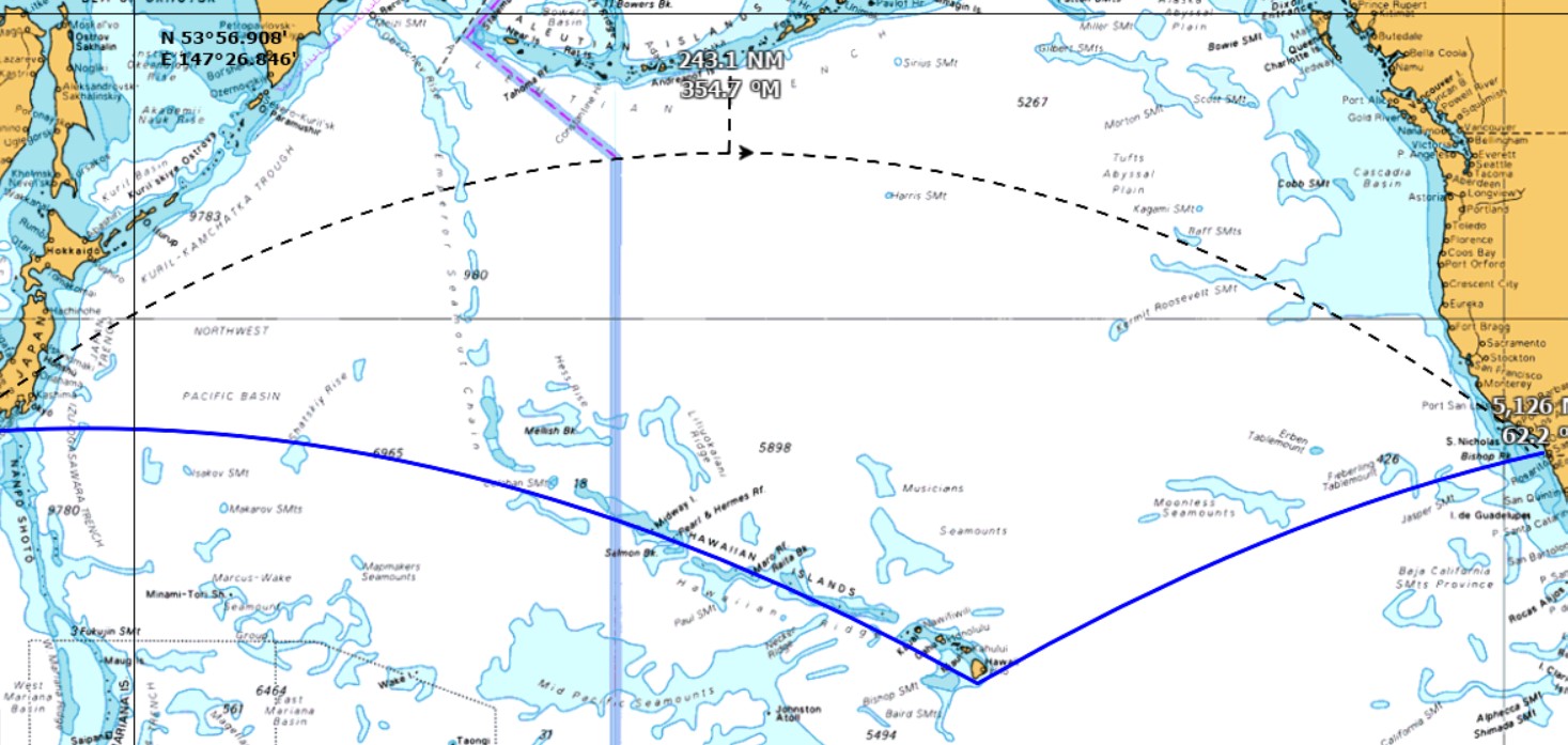
In the Northern hemisphere, great circle routes push north then south again. As you can see from the chart, the dotted great circle route takes you really far north - within 250 miles of the Aleutians. San Diego and Osaka are on almost the same line of latitude (33° North), but you have to sail to 48° North to follow the Great Circle. The midpoint of that route is 900 miles north of both cities.
Sailing south to Hawaii first is longer, but it's a lot nicer.
North Pacific Currents, Wind, and Weather
The currents, wind and weather patterns work against the Great Circle route, making it even less favorable than just a trip to the Aleutians.
Northern Pacific Currents
The North Pacific Gyre currents are a large, clockwise rotation with North Pacific currents near Alaska pushing from West to East below the West to East Aleutian current. Below Hawaii, the North Equatorial currents push towards the West.
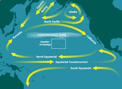
So if you sail the Great Circle Route, you'll be sailing north and west right into the teeth of the North Pacific and Aleutian currents. But the southern route brings you to favorable current. The currents in the North Pacific are complex, but wise sailors avoid bucking the larger, global patterns.
Trade Winds
South of latitudes 32°N, you'll find the Northeast Trades - reliable and consistent winds so constant they were the backbone of trade patterns in the age of sail. North of 35°N, variable winds are replaced by westerlies. So much of the direct route is upwind.
Tropical Storms
Cyclones and Typhoons do not reach the areas of the northern great circle route. But you will finish in Japan, and once you get further south, you may be subject to storm risks. Sailing in winter avoids typhoons off Japan, but will get you nasty conditions in the North Pacific.
Given the disadvantages of weather, current, and prevailing wind patterns, it would take a very compelling reason to pick the Great Circle route over the southern route by Hawaii.
When to Make the Passage
Timing this passage is tricky. This is the point where we learn one reason so few cruisers make it to Japan! You've got to work around Typhoon season and winter storms, and the North Pacific cyclone/hurricane season.
The best time to leave Hawaii for Japan is the end of March, in very early spring, to arrive before the typhoons. Or in November, to slip in between typhoon season and winter storm season.
Unfortunately, if you're going to leave Hawaii before the end of March, you've got some cold spring sailing from California in early March. You could leave at the end of hurricane season in October for Hawaii, then leave from Hawaii in November. Or you could even try it in one long sail around Hawaii if non-stop sailing is your preference.
If you don't have a time crush, you can make a more pleasant sail to Hawaii in May, spend the summer wearing leis and drinking from coconuts, then strike out again in November. The choice is yours, but I think I know how I might do it.
What to Expect Along the Way
Much of this article speaks of hard conditions you might face, but most of those are if you choose the northern route. If you go the far more pleasant but longer route, you can expect good sailing conditions for much of the trip. Since you've sensibly headed towards the equator instead of away from it and you're following the favorable wind and currents and timing around the storm seasons, you’ve set yourself up for a better voyage.
Stop Offs
The great circle route from the Big Island of Hawaii takes you almost straight out along the Hawaiian Island Chain towards Midway. However, it also puts several large coral reefs and shoals in your path. Midway Island and Laysan Island are two of the larger landmasses along this route, but these are protected historical and ecological sites. You might need to get a permit to land and may even get one, and you'll have to check in with the authorities even if you just pass too close.
If you don't have plans to visit and all required permits, you may do better to plot your course further south to avoid the various reefs and atolls along the way.
Once you pass Midway, there isn't very much to stop on until you get to the islands and archipelagos off the coast of Japan.
Weather and Conditions
If you've done your planning well and you've avoided any major weather systems, you can expect a pleasant sail on the southern route with good winds down in the trades and favorable current. It's important to keep monitoring weather though, so you don't get surprised by any storms or severe conditions. It doesn't have to be a named cyclone to kick you around offshore.
What's Your Average?
When estimating trips like this, it's the average speed you can sustain which an accurate estimate. On my boat, we plan trips at seven knots, which is 168 nautical miles per day. We've had days over 200 miles, but it's not the norm. One of our fastest trips - from the Galapagos to the Marquesas - was 3,000 miles in about sixteen days. But we still only averaged a little over eight knots; not much over our planning speed on average.
In the end, that's why the northern great circle route will take longer. Maybe even a lot longer. If you've got even a knot of unfavorable current on a boat like ours, that would add five days to this trip. And a current behind us could shave five days off the trip.
That's not even considering the extra sailing you'll have to do upwind, tacking across unfavorable breeze and sailing off the rhumb line for more favorable conditions. Or the slowdowns you'll take sailing into bigger waves and chop, and slowdowns for bad northern storms.
Did you find the answer to your specific question?
👍 8 👎 1

Leave a comment