How Long Does it Take to Sail Across the Atlantic? (With Maps)
I'm checking my map here, and I'm just curious: how long does it take to cross the Atlantic? In this article, I'll answer the question for the most common sailing boats and routes.
So there's a short and a long answer. If you want the short answer, here it is:
How long does it take to sail across the Atlantic? The Atlantic takes about 3-4 weeks to cross. If you're fast, take shortcuts, and get lucky, it can be done in about 2 weeks. If you're out of luck and are without wind for a week or more, or use a slow ship, it can easily take up to one month.
It really depends on how you plan to travel, what type of ship you're sailing, its size, and -of course- your skills and speed. So there you have it. It takes three weeks. But why? If you're in the least like me, you're not at all satisfied with this answer. You'd want the long and detailed answer. If so, read on.

How Long Does it Take to Sail Across the Pacific?
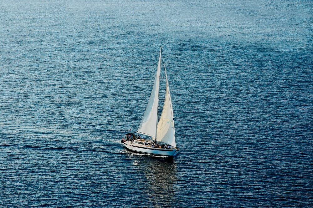
Why Does it Take Three Weeks?
Of course, there are multiple possible routes. For sailing, however, it is advised to make use of the tradewinds (read on for details). The easiest route from East to West follows Portugal - The Canary Island - Cape Verde - Windward Islands. The total distance of this journey on a map is about 6,800km.
A boat rarely sails in a straight line. It most likely will cover more distance due to a curved or S-shaped journey. A good rule of thumb is to add 15-20% on top of the theoretical distance. In real life, you'll travel about 8,000km. This comes down to about 20 days of sailing in good weather.
Please note that sailers prefer to speak of distance (nautical miles), rather than time. You never know what the weather brings. A Nautical Mile is exactly 1.1508mi or 1,852m.
Want to know how far a sailboat can sail in a day? Check out my other article on the average sailing distance in different conditions (new tab).
How to Cross the Atlantic?
Well, I don't suggest you go and cross the Atlantic after reading this article. Sailing open seas is for experienced skippers. I'm including this part to give you a detailed idea of how to do it, and what the journey consists of.
There are two main routes, from east to west and from west to east.
- The Southern passage (which is east to west)
- The Northern passage (which is west to east)
You'll see that both of these routes seem like enormous detours (which they are), but they are the most forgiving sailing route and have worked for over centuries. The routes are dictated by the trade winds. I'll explain them further on.
The Southern passage (east to west)
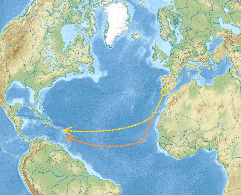
You first need to reach the port of departure. If you travel from Europe to the Americas, you want to sail South-East. Your port of departure will most likely be the Canary Islands, offshore from Western Sahara. Then you will set sail to Cape Verde, offshore from Dakar. Or you'll sail directly to the Windward Island in the Carribean.
The distances of this route are:
- Portugal to the Canary Islands - 750NM (5-7 days)
- Canary Islands to Cape Verde - 850NM (5-8 days)
- Canary Islands to Windward Islands - 2700NM (16-21 days)
This brings your total travel distance around 4000NM and travel time between three and four weeks.
Quickly learn how to use a boat compass with my short beginner's guide here (new tab)
The Northern passage (west to east)
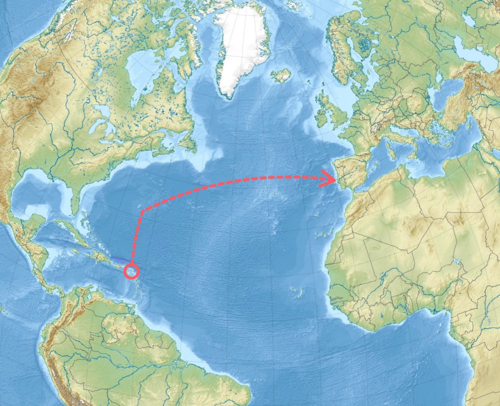
First, you need to reach Bermuda, serving as your port of departure, since it has the best westward winds. Mostly you'd be sailing from somewhere in the Carribean to Bermuda. Then you will set sail to the Portuguese Azores, and from there you'll set sail to the Portuguese coast, and then your final destination.
The distances of this route are:
- Carribean to Bermuda - 850NM (5-8 days)
- Bermuda to Azores - 1900NM (14-17 days)
- Azores to Portugal - 700NM (4-8 days)
- An additional 3-10 days to reach your destination
Your total sailing time will again be between three and four weeks, though this journey will take a bit longer that the westward journey.
Avoiding the hurricane season
Timing also plays an important role in the planning of your journey. Your main concern is to avoid the hurricane season, which lasts from June to November. Most boats leave in November, arriving just in time for Christmas. But the trading winds are stronger in January, making for a faster crossing.
Want to see a handy map with the best sailing season across the globe? Check out my article on sailing seasons here (opens in new tab).
Some info on the Atlantic Ocean
The crossing of the Atlantic is quite a journey. It's the seconds largest ocean in the world, after the Pacific. It covers about 41 million square miles, which is 20% of the Earth's surface. Conclusion: it's big, and you want to be smart about it.
How Hard Is It to Sail Across the Atlantic?
In short: it's as hard you allow it to be.
Sailing across an ocean can seem pretty daunting. I haven't done the crossing myself (yet), but from what I understand, it's actually pretty dull. Bluewater sailing is mostly long stretches of blue, in light airs, cruising at 5 knots. So, in general, it's not super hard.
However, it can get pretty lonely at times. Being alone for 20+ days, with nothing but water and air, can take a toll on you mentally. Most sailors agree that this is the most difficult part of crossing the Atlantic.
It does take some nerve to cross an ocean. Open sea can get quite rough, and when it does, the waves are higher and the winds blow harder than anything you're used to inland.
You should be prepared for these kinds of changes. The most important thing is that you're able to quickly take down a reef. So you should have a simple rig, that allows you to adjust to sudden changes in weather.
If you don't have the experience necessary to deal with heavy weather, you could make (fatal) mistakes. You need to have the confidence that you are in control of your sailboat.
If you want to get into sailing, I recommend you read my article 9 Ways to Learn to Sail for (Practically) Free here.
Also, make sure to bring enough fuel.
How much fuel should you actually carry? It's easy to calculate. Find out how in my article on fuel usage here (opens in new tab).
But what about storms? - A solid boat with a good, capable crew can deal with almost any kind of weather.
I think that if you have the knowledge, experience, and proper gear, it's not difficult. However, if you're unprepared, inexperienced, and unsure about your own capabilities, the great blue could get the better of you.
What Are Trade Winds and How Do They Work?
Luckily our ancestors from the sixteenth century and up were plenty smart. They found the Atlantic had very reliable 'wind roads', which they could use to relatively safely sail to the Americas. These are called trade winds, and they're so useful precisely because they're very predictable. Each new season we can be sure the trade winds bring us to the land of the free. And so they have been used by merchants for many centuries.
In the North Atlantic, only the east-to-west blowing winds are trade winds.

The reason they are called trade winds isn't at all obvious
You might think that, since we've used them for trading so much, so we'd call them after the trade. But it's actually the other way around. The word derives from the Late Middle English trade, which means path or track. The winds were first called trade winds, and then we've named our commerce after them. In the eighteenth century, the word trade comes to mean 'commerce'.
So how do these trade winds work?
In the dead center of the Atlantic basin, there's a large area of high atmospheric pressure. We know it as the Azores High, and it stretches all the way to Bermuda. Hot air rises in tropical regions below, after which it cools at higher altitudes, and comes down near the poles. This indefinite transaction creates wind.
Because of that, there's a dead zone in the center of the Atlantic, where there's or no wind at all, or hurricanes. The reason the winds are so predictable, and nearly always blow in the same direction, is due to the rotation of the earth (this is called the Coriolis effect). The current also moves in this direction, creating a comfortable ride.
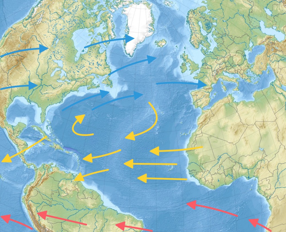
If we line up our routes with our trade winds, you'll notice they line up perfectly.
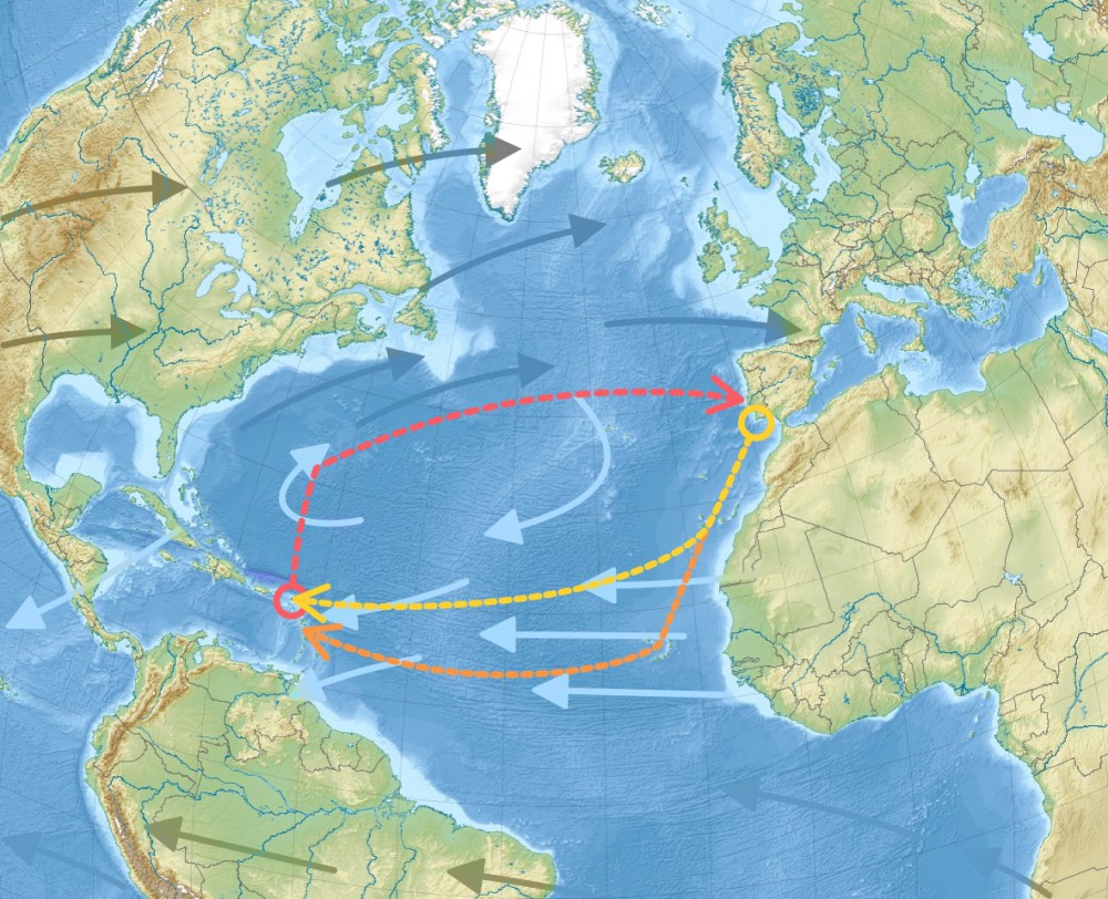
You can learn more about the prevailing winds and their origins in this excellent article at Yachting.com.
My Favorite Beginner Cruising Gear
For passages like these, you need sound navigation gear. It doesn't have to be expensive. Here are my top 3 items:
- Chartplotter: Garmin echoMAP CHIRP 74cv (check current price at Amazon)
- Compass: Ritchie Navigation Explorer (check current price on Amazon)
- Backup GPS: Garmin Strike 4 (check current price on Amazon)
For more details on each one, head over to my recommended gear section.
Related Questions
How long did the Atlantic crossing use to take? In 1492 it took Columbus two months to cross the Atlantic. In the 18th and 19th century, it still took on average six weeks. If weather conditions were bad, it could take up to three months.
So why are we faster now? The wind hasn't increased (or maybe it did, how can I possibly know?).
Why does crossing the Atlantic take less time nowadays? It's mostly due to improved sailing technologies; the shape of the hull, the overall efficiency of boats, and, of course, improved navigation techniques. And sailing boats nowadays use an engine to keep going once the wind lays down. Which, you can imagine, will make quite the difference.
Did you find the answer to your specific question?
👍 134 👎 7


Comments
entreri
I really enjoyed reading this article and learned a few things. Maybe one day I will embark on such a journey. :)
Stavroula
Great Easy text! Thank you so much! I am thinking and reading about this journey a long time.. I might do it.. nice article!!
James Hospedales
Enjoyed your article, which I read because I need to cross the Atlantic but don’t want to pay the carbon cost to the planet. The future of sustainable tourism and travel will have to return to using these ancient “tracks”. This will be among the messages of EarthMedic.
Roy cumming
Good information and written so a novice can understand it.
Jeko Vili
I have never sailed in my life but I am planing to learn and go from Florda to Batumi, 🇬🇪 Georgia. Great article btw!
John Bowman
Great article really put in terms a beginner sailor can understand, especially the Trade winds. You have a great site and I enjoy reading everything
Cool Breeze
Thanks for sharing. My Pake and I enjoyed sailing and spent never enough time on the water. My family is originally from Marrum and Holwerd. I look forward to one day sailing across the Atlantic.
Adi
Hi!
I really like your blog posts and wondered if there is any chance to get in touch either via e-mail or https://yachting.com/en-gb/ to cover/share some of the content and cooperate?
Many thanks for considering my request. :)
Martin Richardson
I’m a healthy/fit retired person that has dreamed of taking on a challenge of a trans Atlantic sail East to West. What a great tale it would be to buy a sailboat in France and sail it back to the States. My sailing experience has been mostly in the BVI’s.
My question is: Since I don’t possess the necessary skills, how would one go about hiring a experienced skipper to make the trip with me.
Michael Hearns
Thanks so much, very informative, I will be reading again…
Jason
Great article.
Cassandra
Very enjoyable read! I would like to cross myself but my other half wants to go the other way!
DGH
“The most important thing is that you’re able to quickly take down a reef.” Usually we say, “to reef” or “put in a reef”. This made it sound like you’re actually taking OUT a reef. Or shaking out a reef. Which is what you do when the wind lightens a bit. :)
Wooo! Hunavejohnter@gmail.comLike this massage keep it up.
it is so inspirational
Hugh Tetley
There is some good information in your article, but also some heavy errors.
I have done multiple Atlantic crossings since the 1950’s.
The worst error is that you don’t have you own crossing experience, which means you are only relaying second hand information.
Reliance on electronics is only for fools.
You mention GPS and back up GPS.
The only back up is charts and a compass .. if you keep sailing west, then eventually you are going to reach land.
I sail with a fifty year old Shipman 28 and all I ever use are charts and compass. Not even a sextant .. and I’m still alive.
It is essential to have knowledge, tools and materials to do repairs. Ocean crossings create a lot of wear and tear, particularly with sails.
Now, there are far too many spoilt idiots in supermarket level boats, especially catamarans of dubious quality and suitability who give up (and cry about it on social media) or need to be rescued.
Romin de Globein
I totally agree with Hugh Telley.
All second hand info and assumptions from a writer with no experience.
Too much pretty this and pretty that.
Living in Nederland i’ve never seen the “great lakes” of Friesland.
Diocleciano Pereira
Tenho 80 anos e sou proprietário de um barco gibsea 31” de 1981 e já atravessei o Atlântico 4 vezes em solitário, fui e vim aos Açores 7 vezes das quais 6 vezes em solitário. Se você ama o mar e navegar nunca é aborrecido, como diz. è importante ter conhecimentos, mas não é difícil. Em junho deste ano partirei em solitário mais uma vez para os Açores onde estarei por 2 a três meses visitando todas as ilhas que são lindas. NAVEGUEM
Leave a comment