Sailing Route from Florida to the Virgin Islands (with Map)
Sailing from Florida for the Virgin Islands is a dream for many, what’s not to love about a slow island hop south? Many people do this, and it can be a fantastic experience, but not without a few caveats. And it's not the only way to make the trip.
Two routes from Florida to the Virgin Islands:
- The Thorny Path - nearshore route, through the Bahamas, Turks, Caicos, along the Dominican Republic and Puerto Rico.
- I-65 - offshore route, east to longitude 65°W before turning south to the Virgin Islands.
The two principal routes from Florida to the Virgin Islands are the Thorny Path and the I-65 Expressway. The Thorny Path is a nearshore route, picked through the Bahamas and Turks and Caicos, then along the Dominican Republic and Puerto Rico to the Virgin Islands. "I-65" is an offshore route that takes you east to longitude 65°W to avoid the trade winds before turning south to sail across them instead of dead upwind.
Both routes have advantages and disadvantages to consider, so read on and we'll help you decide which might be the best way for you.

Minding the Trade Winds
The trade winds in the Atlantic are the most important factor in how you sail to the Caribbean. They start around 22°N to 25°N, and blow from an easterly direction. Mostly it's southeast, but in November and into the winter there's often a northerly component.
The trades blow 15 to 25 knots most times and are consistent in direction. With them on your beam or behind you, they make for lovely sailing. But on the nose, they make for a long, uphill slog which can carry on for days.
Because of the strong easterly component, you're going to deal with the trades when you're headed to the eastern Caribbean. Whether your approach is to sail around them until they're helpful, or sail into the teeth of them during light days and lulls, the trade winds dominate how you plan your route.
I-65 - Offshore and Fast
Whether you're sailing to the Virgin Islands from Florida or New England, the approach is pretty similar. You'll need to get east to reach the Virgin Islands, and you don't want to sail upwind into the trade winds. So no matter where you leave from, you sail east until about 65°W, then you turn south and sail straight for the Virgin Islands with the trade winds as more of a reach than a beat to windward.
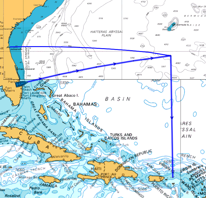
Leaving from Florida, the further south you leave the more north you may need to make with your easting. If you're leaving south of Port St. Lucie, you need to head north to miss the Bahamas, it may be better to make your way up the coast and leave from further north.
From points further south like Ft. Lauderdale or Miami, you will have a lot of extra sailing to get around the Bahamas. These aren't great places to plan on the I-65 route, and most who head this far south do so intending to head to the Bahamas and take the Thorny Path.
How Safe is I-65?
The I-65 route is a true offshore passage. You will be several hundred miles off shore and beyond the reach of rapid rescue at some points. Sailing the North Atlantic - even towards or in the tropics - isn't without risks. It's not a trip for inexperienced or unskilled sailors, so if it's your first time offshore you should think about bringing some experienced crew or sailing in company with more experienced boats.
Weather and Hurricanes
The biggest risk sailing the offshore route is foul weather. The summer months from May through October are prime hurricane season. A busy year like 2020 saw thirty large storms, fourteen of which were hurricanes. Of those, seven hurricanes were Category 3 or stronger.
That's one nasty storm per week and a hurricane about every other week for the six month season in a bad year. Depending on boat speed, you may be offshore from seven to twelve days, more than enough time to be on the water with a serious weather system. Not every Atlantic system will cross your path, but a hurricane can be 300 miles wide, and will disturb weather far outside the direct impact of being in the middle of the storm. You can get Tropical Storm force winds (34 to 63 knots) 300 miles from the center of a hurricane.
Unfortunately, while the winter doesn't have hurricanes, it still has nasty storms and terrible weather. These storms come from the north, and can be unpleasant and dangerous.
The Gulf Stream
You'll have to cross the Gulf Stream on any trip east from Florida. This strong, warm current runs north along the coast of Florida some sixty to ninety miles offshore. How far offshore varies with where you are, as well as the state of the stream - it moves around a bit. Currents can be as high as 3.5 knots off Florida. It's about 60 nautical miles across, not a long way, but if you're doing six knots that current can push you thirty miles off course if you don't plan for it.
The Gulf Stream can be a delight to sail through, it's warmer and a brilliant cobalt color, and you'll notice an almost instant change in air and water when you cross into it.
Unless you try to cross it when the wind has any northerly component to it. Then the warm and friendly Gulf Stream can turn into steep and nasty chop as the wind piles up against the current to make large, fast and powerful waves that pound your boat and slow you to a crawl. Experienced mariners caught in the Gulf Stream in a big northerly describe it as one of the worst offshore experiences they've had.
To cross the stream, stay ready to go in Florida, watching the weather and stream forecasts looking for a day or two clear of northerly winds to make the crossing. You want to give it a day or two after a big northerly to settle down. When you have that lack of northerlies coupled with a decent offshore forecast past the stream, you can go.
When is the Best Time to take I-65?
November. The short, simple answer is November. The longer answer is mid to late November.
Hurricane season runs into November. In 2020 there were two category four hurricanes and a tropical storm in November. Though 2020 was notable for the number and lateness of storms, in a more settled year there’s still a risk before the second week of November.
By mid to late December, the winter storm season in the Atlantic has picked up and the trade winds have freshened. From January onwards the odds of a harsh winter storm are high and sailing offshore is inadvisable.
The Thorny Path - Near Shore and Slow
The Thorny Path has an unpleasant sounding name for a reason - it can be a challenging and uncomfortable. But it is a path you pick among the brambles, not a straight out sprint offshore.
Starting from Florida, you make your way to the Bahamas. The exact route you take to and through the Bahamas depends on where you start from in Florida, what you wish to see along the way, and how long you want to spend getting to the Caribbean. You're going to cross the Gulf Stream, so that section applies to you!
Leaving Florida from the north head to the Abacos, and down through Eleutheria. From further south, you may head for Bimini and Andros before heading through the Exumas. There are so many ways to get from Florida to Georgetown, it's up to you how to do it.
Most head to Georgetown, where cruisers start the least pleasant stretch of the Thorny Path.
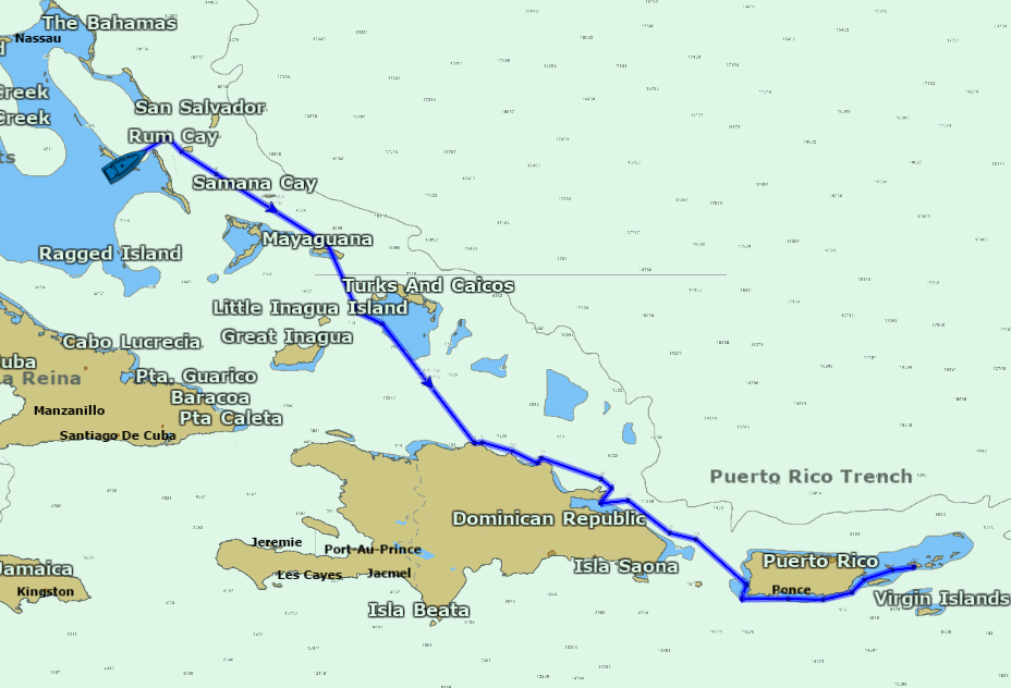
From Georgetown, work your way southeast through the Turks and Caicos, stopping along the way and keeping your individual passages short.
The idea is to keep your sailing to the times when the trade winds will not be very strong in your face. Day sails, short hops, overnight sails, and working with the wind, tides and currents to avoid the worst of the chop and beating to windward are your principal tools.
Eventually you arrive in the Dominican Republic; most cruisers aim for Luperón as point of first arrival, as it's a good place to stage the rest of the trip from. The trip across the Dominican Republic is most often an upwind slog into foul current, but careful trip and route planning and taking your time can minimize some of this.
The Mona Passage between the Dominican Republic and Puerto Rico is another tricky stretch of water. It's only 65 miles between closest points of land, but port to port the leg from Samana, DR to Puerto Real, PR is closer to 145nm. An enormous volume of water from the Caribbean and Atlantic washes through this constricted channel, and currents can be high and unpredictable. Coupled with wind against current, it takes some care and patience to find a good crossing window.
Once in Puerto Rico, the southern coast is a very popular route across the country to the Virgin Islands, with easier sailing conditions and plenty of safe anchorages.
How Safe is the Thorny Path?
The Thorny Path takes you away from the risks of offshore sailing. You will still be in the Caribbean during winter storm season, but not hurricane season. And you won't be offshore, unable to get to a safe harbor.
The major risks in the Thorny Path are rough conditions and the trickier shallows and shoals in navigating the Bahamas and the Turks and Caicos. Since you're only making passages of less than a day in most cases, you can ride out foul weather in safe harbors. But "good" weather on the Thorny Path can still beat up your boat and break things, but it's not like sailing into a storm.
When is the Best Time to take the Thorny Path?
November through May is the best time. This takes you outside of hurricane season and leaves plenty of time to make the transit. Note that the trades winds strengthen in the winter, but that is still better than getting caught in a hurricane.
Resources
Bruce Van Sant, author of The Gentleman's Guide to Passages South: The Thornless Path to Windward, spent years navigating the Thorny Path and assembled good information about how to avoid the worst of the conditions. He tracked various wind phenomena and worked out plans for making moves between safe destinations with minimum risk of adverse conditions. If you're thinking of making this trip, read this book.
Also check Noonsite.com for current information about clearances, ports, and rules regarding immigration in the countries along the way.
Did you find the answer to your specific question?
👍 21 👎 2

Leave a comment